|
|
|
Historic Indiana 316 | ||||
|---|---|---|---|---|
Bluffton | < about 5 miles > | Indiana 301, near Vera Cruz | ||
Cities Served: | Bluffton, Vera Cruz | |||
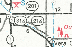
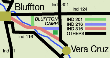
About Ind 316: | At one time there was a system of roads around a state park known as the Bluffton Camp. Amazingly, three different roads around the camp were state roads! Below are a couple of maps showing the roads and trying to label them. While the maps are incomplete because of the detail needed, taken together (and assuming there wasn't any changes in the meantime) they show how the roads were labeled: | |||
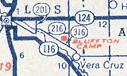 Rand McNally Atlas map of the Bluffton Camp Area, 1951. Bluffton is the slightly concave box on the left, the camp is symbolized by a red box and italicized, capitalized red letters. |
|
Mobil map of the Ouabache Camp Area, 1973. Same camp, different name, location slightly off due to space reasons. | ||
Combining the two above maps, you get this:
My impression of what the roads around Camp Bluffton looked like from 1950 to 1975. | ||||
Indiana 316 was the longest of the three roads in the area, serving as the direct connectin between Bluffton and Vera Cruz. The area road system has gone through some major changes since then. Both 216 and 316 have been decommissioned, and if one were to head west from Vera Cruz up old Indiana 316, one would find a cul-de-sac at the eastern border of Ouabache Campground (old Bluffton Campground) and a park entrance in the way of the original Indiana 316 routing. It would also appear that the former Indiana 216 route has gone through some chopping up as well. | ||||
Western Terminus: Bluffton | ||||
The Western terminus of Indiana 316 has not been photographed for this site. Any and all photos are welcome, along with discriptions. | ||||
Eastern Terminus: Indiana 301, near Vera Cruz. | ||||
| View at the former endpoint of Indiana 316. Indiana 301 comes at you, then turns to the left at the intersection. photo by James Schul; up May 8, 2003 | |||
|
| |||
©2003, Indiana Highway Ends | ||||
